GPS: Unterschied zwischen den Versionen
Aus www.wiki.ardumower.de
(→GPS) |
|||
| Zeile 1: | Zeile 1: | ||
| − | = | + | =Abstract= |
<gallery> | <gallery> | ||
File: ublox_neo_6m.jpg | File: ublox_neo_6m.jpg | ||
| Zeile 6: | Zeile 6: | ||
</gallery> | </gallery> | ||
| − | + | Currently, GPS is used: | |
| + | * To receive current date and time | ||
| + | |||
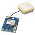
| + | Later, by the help of a GPS receiver (e.g. GY-NEO6MV2, ublox 6m), the long-term position could be calculated. Therefore, the GPS position values are averaged. | ||
= Wiring: = | = Wiring: = | ||
Version vom 16. September 2014, 09:53 Uhr
Inhaltsverzeichnis
Abstract
Currently, GPS is used:
- To receive current date and time
Later, by the help of a GPS receiver (e.g. GY-NEO6MV2, ublox 6m), the long-term position could be calculated. Therefore, the GPS position values are averaged.
Wiring:
GPS TX (3.3V compatible) -- Arduino RX
GPS RX (3.3V compatible) -- Arduino TX
GPS VCC -- Arduino VCC 5V
GPS GND -- Arduino GND
Visualization of GPS data
GPS data (course, speed, position etc.) can be plotted by pfodApp:
Fusion of sensor values
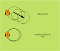
- Calculation of short-time position by Odometry and Compass
- Calculation of long-term position via GPS
A Kalman filter can be used to fusion all sensor values.


